How To Find Your Property On FEMA’s Flood Insurance Rate Maps

What are FEMA flood maps?
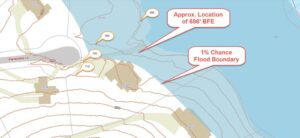
FEMA’s Flood Insurance Rate Maps (FIRMs) or just Flood Maps are provided after a flood risk assessment has been completed or updated for a community.  This study is known as a Flood Insurance Study.  The FIRM gives you the Base Flood Elevations (BFEs) and insurance risk zones in addition to floodplain boundaries.  The FIRM may also show a delineation of the regulatory floodway.

Once the “insurance risk zone”  (commonly referred to as the flood zone) is determined, actuarial rates, based on these risk zones, are then applied for newly constructed, substantially approved, and substantially damaged buildings.  FEMA uses these rates to determine the insurance rate you will pay for flood insurance

FEMA’s Digital Flood Maps

FEMA discontinued the production and distribution of paper flood maps in 2009 as part of its Digital Vision Initiative. This affected all the Flood Maps, boundary information, and study reports. However, clients can still view the products for free through their website or buy them in digital format.

To view these flood maps online, go to FEMA’s Map Service Center and key in your address (hi-lited area shown here) search for your home.  This will prompt you to then select the map that covers your area.  The Flood Maps are somewhat cumbersome to use online. It is best to go through the tutorial on the bottom right of the address search page for an easier and more effective use of the GIS map.

author avatar
Surveyor

More Posts

Flooded urban street with a warning sign highlighting the need for improved drainage design
civil engineering
Surveyor

Developers Push for Smarter Drainage Design Standards

Last weekend’s heavy rain turned Dallas streets into rivers. Videos of cars stuck in water and flooded neighborhoods filled social media. For developers and property owners, those scenes weren’t just shocking—they were a wake-up call. The city’s fast growth and stronger storms are putting pressure on how projects handle drainage

Read More »
Aerial view of a residential lot with contour lines showing elevation details from a topographic survey.
land surveying
Surveyor

How to Scope a Topographic Survey That Passes Review

If you’ve ever tried to build, remodel, or add a new structure to your property, you probably know how tricky the city’s permit process can be. Between floodplain rules, drainage requirements, and the DallasNow online system, it’s easy to get stuck waiting for approval. One of the biggest reasons for

Read More »
Technicians inspecting an underground utility access point near a home, representing how an ALTA survey helps document service lines and hidden utilities.
alta survey
Surveyor

ALTA Survey Tip: Before You Snap That Pipe Photo

If you live in Dallas, there’s a good chance you’ve received a letter from the city about your home’s water service line. The notice asks homeowners to check what kind of pipe connects their house to the water meter and upload photos to an online form. At first glance, it

Read More »
Aerial view of a dense urban district showing rooftops, streets, and public spaces where stormwater design plays a critical role
civil engineering
Surveyor

Stormwater Design Lessons from a Mega Campus Build

When Goldman Sachs released images of its new Dallas campus this week, most headlines focused on jobs, office culture, and architecture. But for civil engineers, the real story is different. An 800,000-square-foot campus in the middle of Victory Park highlights a challenge every Dallas developer faces: stormwater design. Stormwater design

Read More »
Commercial retail construction site with cranes and concrete framework, showing why an ALTA Land Title Survey is essential before development
alta survey
Surveyor

Why Every Retail Project Needs an ALTA Land Title Survey

When news broke that H-E-B finally secured approval for its first Dallas store at Hillcrest Road and LBJ Freeway, the buzz was immediate. Shoppers were excited, but neighbors raised concerns about traffic jams and possible flooding around the site. These issues go far beyond grocery lines—they highlight why an ALTA

Read More »
Busy city intersection with heavy traffic and surrounding buildings showing how property surveys guide rezoning and development
boundary surveying
Surveyor

How a Property Survey Shapes Rezoning Battles

When Dallas residents heard that H-E-B planned to open its first store inside the city limits, excitement quickly mixed with concern. For many, the thought of new jobs and fresh groceries sounded great. But for neighbors near Hillcrest Road and LBJ Freeway, the project raised questions about traffic, safety, and

Read More »